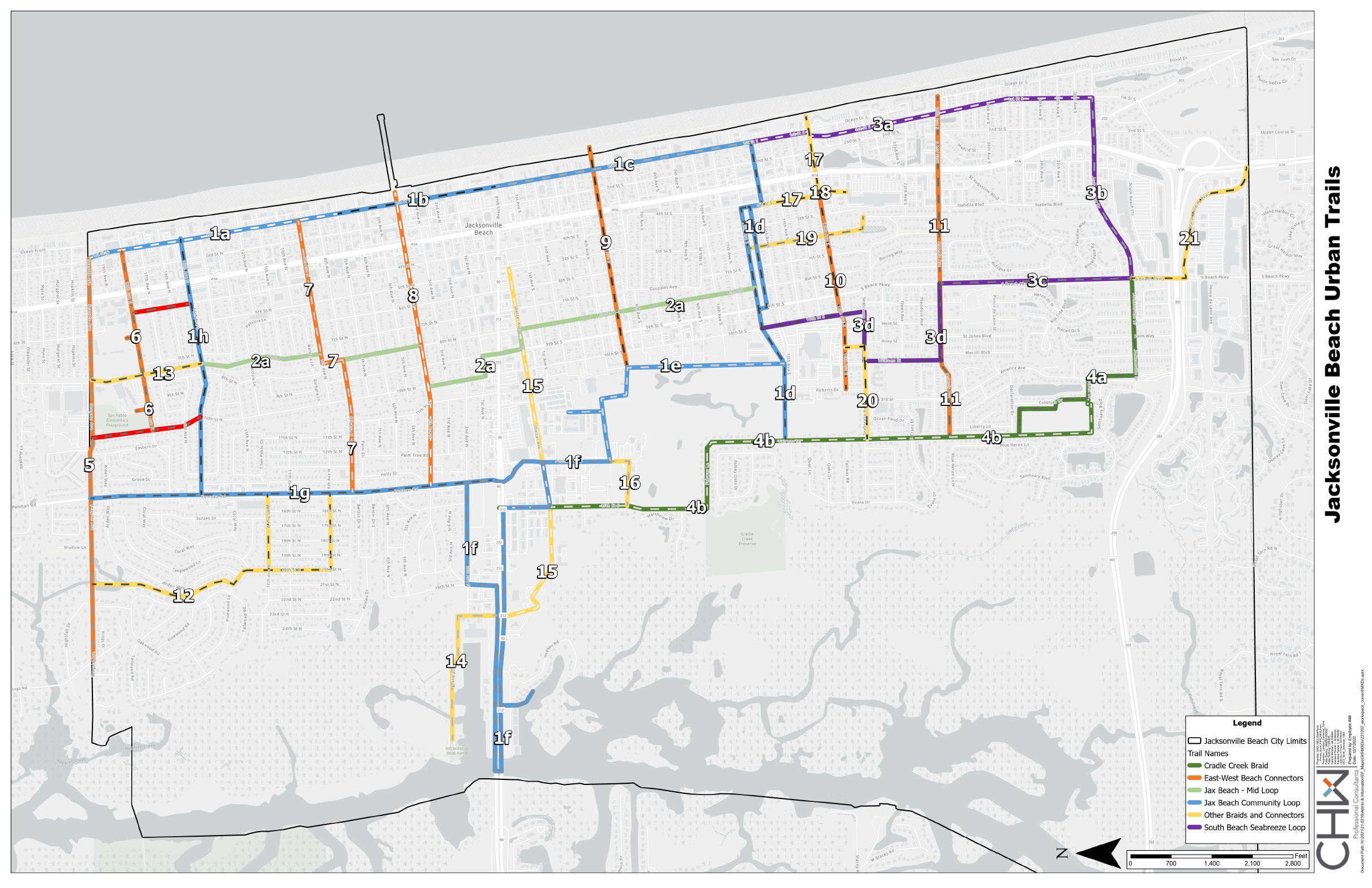
To improve pedestrian and bicycle safety as well as provide our residents a network of trails to get around Jacksonville Beach easily, the City of Jacksonville Beach hired consultants CHW to obtain public input and develop the Urban Trails Master Plan. In December 2022, the Jacksonville Beach City Council approved the Urban Trails Master Plan (see the proposed routes in the above map).
It is important to note, the routes on the above map are conceptual. The actual design of the routes will be determined on a case-by-case basis and will take into account lowest overall cost, fewest conflicts with utilities and obstacles, width of public right-of-way, existing sidewalks and other relevant factors.
ABOUT THE URBAN TRAIL MASTER PLAN
This Urban Trails Master Plan provides a framework for implementing a comprehensive trail system. Working with consultants and utilizing public input obtained from discussions with the community, the trail plan identifies the following:
- A vision and framework for a city-wide, multi-use trail system.
- Links between neighborhoods, beaches, parks, commercial focal points, and natural areas.
- Routes, providing design parameters and concepts for various facility types.
Design concepts were developed using best practices with considerations for the desired user groups.
The mission of the Jacksonville Beach Urban Trails project is to create a multi-modal urban trails network for the City of Jacksonville Beach that provides safe access and usability for all ages and abilities of residents and visitors.
The Goals and Objectives for the Urban Trails Master Plan are:
- Connectivity: Connect the City’s multiple green spaces and parks into the overall network to create a comprehensive looped system, including the golf course.
- Accessible: Provide shared use paths for users to enjoy recreationally and to traverse from important origins and destinations throughout the City.
- Safety: Prioritize safety for all users through separated trails, the use of lighting and safe, dedicated crossings (particularly A1A).
- Sense of Place: Develop a complete wayfinding system to assist users in navigating the trail network and reinforce the strong sense of place of being in Jacksonville Beach
- Multi-Modal: Accommodate a wide range of multi-modal travel including pedestrians, bicycles, strollers, roller bladers, skateboarders, and scooters.
- Policy: Provide policy recommendations and guidelines for improving transportation connectivity and mobility throughout the community.
For more information about the project: URBAN TRAILS MASTER PLAN PROJECT
Read Frequently Asked Questions
Read final report here: URBAN TRAILS MASTER PLAN FINAL REPORT
It is important to note the Urban Trails will be installed on the City’s public right-of-way and will not be installed on private property.
URBAN TRAILS UPDATE AS OF JANUARY 10, 2024:
At the January 10, 2024 City Council briefing, the City Council discussed the next steps for the Urban Trail project after reviewing the comments and concerns submitted by citizens at the December 13 Community Meetings. For more information, you can read the Community Meeting Comments and Responses.
As a result of the concerns raised by residents, the City Council came to a consensus that the next steps for the Urban Trails project will be as follows:
- The width of the Urban Trail sidewalks will be reduced to 7.5 feet. This is the width of the Urban Trail segment most recently installed on Jacksonville Drive and the width is sufficient to allow walkers and bikers to pass each other safely. 7.5 feet is also the width of the multi-use path in Neptune Beach along Florida Blvd. Atlantic Beach has an 8 foot multi-use path along Seminole that is comfortably used by pedestrians and bicyclists. It may be possible to install a 10 foot sidewalk in some places where there is more space. But, 7.5 feet is preferred in our neighborhoods where there may be less space available for a larger sidewalk.
- The City will focus on implementing TWO of the trail segments as examples so residents can see exactly what the Urban Trail will look like and how it will work. The hope is that these examples will help to address concerns citizens may have about the concept of the Urban Trail network. The two trails to be implemented first will be:
- Trail 7: 8th Avenue North from Penman Rd to 10th Street North then 9th Avenue North to 1st Street North.
- Trail 3(b): Jacksonville Drive from South Beach Parkway to A1A.
- The City will also take a more “holistic” approach to the design of the other two segments to take into account all the issues associated with each segment (road, drainage, neighborhood characteristics, etc.). Parks and Recreation will work with the consultants CHW to re-evaluate the following segments:
- Trail 1(h): 15th Avenue North from Penman Rd to 1 Street North.
- Trail 8: 4th Avenue North from Penman Rd to 1st Street North.
- To hear the Council Briefing audio discussion about the Urban Trail project, you will have to download the January 8, 2024 Briefing Audio. Note: the Urban Trail discussion starts at 56:17:
For the most recent news, updated information and timelines, and an FAQ, CLICK HERE. This link now includes the City’s responses to comments and questions from the December 2023 Public Meetings.
URBAN TRAILS UPDATE AS OF DECEMBER 15, 2023:
East-West Routes are First Priority:
The City Council has prioritized installing East-West routes to help residents who live on the west side of Jacksonville Beach get safely to the beach. As such, there are several trails in District 3 that will be the first trails to be constructed.
City of Jax Beach recently concluded negotiations with our Design Consultant for the design of the following Trails:
-
- Trail 1(h): 15th Avenue North from Penman Rd to 1 Street North.
- Trail 7: 8th Avenue North from Penman Rd to 10th Street North then 9th Avenue North to 1st Street North.
- Trail 8: 4th Avenue North from Penman Rd to 1st Street North.
- Trail 3(b): Jacksonville Drive from South Beach Parkway to A1A.
- Preliminary designs were completed for the 4 trails and you can view the URBAN TRAIL CORRIDOR DESIGNS
- Two Community Meetings were held on Wednesday, December 13. At the Community Meetings, the consultants CHW provided a presentation about the development of the Urban Trail Master Plan. Jacksonville Beach staff also provided presentations about the history of the project as well as information related to frequently asked questions about the project. There were also viewing stations for each of the trail designs so citizens could talk one-on-one with a representative, ask questions and provide feedback on the proposed design. Citizens could also submit comment cards. Parks and Recreation staff plan to follow up on the submitted comments.
- After the Community meetings, the designs with be finalized and the consultants will provide final designs and bid specifications so we can solicit bids for constructing these trails.
- Based on this timeline, we expect construction to begin in the summer 2024.
For property owners who have landscaping, structures or pavers in the right-of-way where the urban trail is proposed, these issues will be governed by the Revocable Encroachment Permit that exists for your improvements in the right-of-way.
WHAT IS A REVOCABLE ENCROACHMENT PERMIT?
The Revocable Revocable Encroachment Permit is obtained when a property owner wants to place an improvement or erect a structure (i.e. a fence or other built structure) in the right of way adjacent to their property. You can see the conditions of the REVOCABLE ENCROACHMENT PERMIT.
URBAN TRAILS PROJECT HISTORY
- In 2019 and 2020, the City of Jacksonville Beach held Community Conversations to get feedback from residents on their vision for Jacksonville Beach. The City also held Community Conversations with businesses to understand their vision for Jacksonville Beach.
- In 2021, the information gathered from the Community Conversations was used by the City Council to develop a Strategic Plan for the City of Jacksonville Beach.
- Based on input from the Community Conversations, the consistent feedback received from residents was the desire for improvements so residents could walk and bike safely throughout Jacksonville Beach. So, the City launched the Urban Trail Master Plan Project to improve pedestrian and bicycle safety and mobility throughout the community.
- The first Community Meeting about the Urban Trail Master Plan Project was held October 27, 2021 to get input from residents; an additional 5 public meetings were held, with the final pubic meeting in March 2022. You can read updates about the Urban Trail meetings in the following monthly newsletters:
- December 2020 News
August 2021 Newsletter
October 2021 Supplement – Urban Trails Master Plan Community Meeting
November 2021 Newsletter
January 2022 Newsletter
February 2022 Newsletter
February 2022 Newsletter Supplement
March 2022 Newsletter
July 2023 Newsletter - The City Council approved the consultant’s final report on the Urban Trail Master Plan in December 2022.
- In early 2023, the City Council discussed priorities for the Urban Trail Master Plan and the consensus was that East-West routes should be addressed first to provide residents who live west of Penman and 3rd St, safe routes to the beach.
- Parks and Recreation and Public Works identified 4 East-West routes to focus on:
- 15th Ave N
- 8th Ave N/9th Ave N
- 4th Ave N
- Jacksonville Drive